Carretera Austral: Road Trip Patagonia
In the south of Chile, from Puerto Montt to Villa O’Higgins, runs the famous Route 7: the Carretera Austral. This 1,200-kilometer road takes you past spectacular viewpoints and countless incredible hikes. This part of Patagonia is still less well known among backpackers and therefore much quieter than, for example, Torres del Paine National Park, which lies further south. In this article, we share a complete road trip itinerary for driving the Carretera Austral, including a downloadable guide and a Google Maps map.


Officially, the Carretera Austral runs from Puerto Montt to Villa O’Higgins, but we only drove the route as far as Cochrane. The itinerary below is based on our own experiences and includes tips and hikes up to the town of Cochrane. If, like us, you need to drive the route both ways, stay one night in each place and stop at exactly the same spots on the return journey. In our Carretera Austral Travel Guide you’ll find a more detailed description of the different options for traveling this route.
Carretera Austral: General Itinerary for a Road Trip
Below you’ll find a general Carretera Austral itinerary that starts in Puerto Montt and ends in Cochrane. Continuing to Villa O’Higgins requires an additional day of travel. Do you need to drive the route round trip like we did? Then check out our other article with a specific itinerary for the Carretera Austral.

Detailed Itinerary and Activities on the Carretera Austral
Day 1: Puerto Montt – Hornopirén
Distance: 110 km
Activities: pick up rental car, grocery shopping, short ferry crossing
The first day of the Carretera Austral is mainly practical: you pick up your rental car and do some grocery shopping in Puerto Montt. We did this at a large supermarket where prices seemed quite reasonable. After that, you continue on to Hornopirén, which requires a short ferry crossing. You don’t need to book this in advance, but it can be helpful to check the schedule beforehand. We didn’t, and luckily we were able to board the ferry right away.
Day 2: Hornopirén – Chaitén
Distance: 150 km
Activities: Hornopirén–Caleta Gonzalo ferry (book in advance*), hikes in Pumalín Douglas Tompkins National Park
The ferry crossing to Caleta Gonzalo takes about 5 hours, although the exact time depends on the route. We read that sometimes you have to get off the ferry, drive a section, and then board another ferry. Our crossing was direct, which was very pleasant. During the journey you can go down to your car to prepare lunch, and you can also buy small items on board.
From Caleta Gonzalo it’s about a one-hour drive to Chaitén. If you still have energy, we recommend the hike to the volcano. This hike takes 2 to 3 hours and involves quite a bit of elevation gain. All in all, it makes for a long day, so you could also save this hike for Day 3—although that would mean driving part of the route again. Right after disembarking from the ferry, there is also a 3-kilometer hike starting on the right-hand side. In our Google Maps map of the Carretera Austral we’ve saved all the hikes between the ferry and Chaitén.


*It may happen that your desired dates do not appear on the website. This means the ferry has not yet been confirmed. In that case, check again about two weeks beforehand, as the ferry does run daily.
Day 3: Chaitén
Distance: 50 km (round trip)
Activities: Pumalín Douglas Tompkins Park
Depending on what you managed to do the previous day, today you can choose the hike you still have left. Douglas Tompkins Park is quite large, and about 20 kilometers beyond Chaitén there is another entrance. From there you can do around three different hikes. We did the short one, but we would definitely recommend the viewpoint hike or even the full-day hike, which takes about 6 hours. With good weather, you can already see the glacier from the entrance.
Tip: if you enjoy hiking and have enough time, it might be a good idea to spend an extra night in Chaitén. That way you’ll have time to do all the hikes in the area, including those near the ferry. The weather can also change suddenly, which may prevent you from hiking for a day.


Day 4: Chaitén – Futaleufú
Distance: 150 km
Activities: Corcovado National Park
Today’s final destination lies off Route 7, and the last stretch is mostly gravel. Futaleufú is a small town with beautiful views of the river. Schedule a rafting activity for the next day and, on the way to town, don’t miss the hike to the Yelcho Glacier in Corcovado National Park.


Day 5: Futaleufú – Villa Santa Lucía
Distance: 80 km
Activities: rafting in Futaleufú, Futaleufú viewpoint
Start the day with a river activity (we didn’t do this because we traveled in November and didn’t feel the weather was ideal for water activities). Afterwards, you can drive to the viewpoint marked in our Google Maps Patagonia guide. This route is perfectly doable with a regular car, although some sections are quite steep. In the afternoon, drive on to Villa Santa Lucía.
Day 6: Villa Santa Lucía – Puyuhuapi
Distance: 120 km
Activities: Hanging Glacier, waterfall
The drive to Puyuhuapi isn’t very long, and if the weather is good, you can already visit the Hanging Glacier today. It’s best to go when it’s not too cloudy, otherwise you won’t see much. This is the first park on the Carretera Austral that charges an entrance fee and requires advance reservation. The longest hike, which brings you closest to the glacier, has been closed for maintenance for quite some time. Still, you can do several short hikes with views of the glacier (even if Google currently indicates the park is closed).
On the way to Puyuhuapi you’ll pass a waterfall visible from the road. It’s nice to stop briefly, but not essential.


Day 7: Puyuhuapi – Coyhaique
Distance: 240 km
Activities: Hanging Glacier
Is the weather better today than yesterday? Then start the day by visiting the Hanging Glacier. If you leave on time, you’ll have enough margin to drive to Coyhaique. You’ll notice that gravel sections become more frequent, which makes the drive take longer.
Day 8: Coyhaique
Distance: 0 km
Activities: grocery shopping
In Coyhaique it’s time to stock up properly, as the supermarkets are larger and prices are lower. Along the route you’ll also find minimarkets, but prices there can be up to three times higher—we even saw bread priced at €6 per loaf. Coyhaique is also large enough for a walk around town, although there aren’t many standout attractions. There is a national park in the surrounding area.
Day 9: Coyhaique – Río Ibáñez / Villa Cerro Castillo
Distance: 100 km
Activities: hike to the lake in Villa Cerro Castillo
It’s a short drive to Villa Cerro Castillo, where you can do a popular hike to a lake. The round trip is about 13 kilometers with significant elevation gain. In the end, we didn’t do this hike because it costs several dozen euros: you have to pay for parking and also per person for the hike. Instead, we went to Río Ibáñez, where we stayed in a rustic cabin. The road there is mainly suitable for 4×4 vehicles, but we managed to get to within about 500 meters of the campsite. The surroundings are beautiful. Make sure to stop at the waterfall you pass on the way to the campsite.
Tip: from Coyhaique it’s about 100 kilometers to the start of the hike, so you’ll need to leave early or do the hike first thing the next morning before continuing to Puerto Río Tranquilo. Also plan extra time to enjoy the views along the way.

Day 10: Río Ibáñez / Villa Cerro Castillo – Puerto Río Tranquilo
Distance: 120 km
Activities: viewpoints, book Marble Caves tour
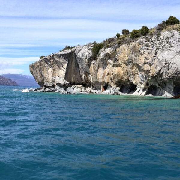
Today you’ll spend most of the day in the car, although the drive doesn’t take the entire day. You can also choose to first do the hike to the glacial lake in Villa Cerro Castillo. On our map we’ve saved several stopping points to enjoy the scenery. In the evening, book your Marble Caves tour for the next morning. In high season you may need to book earlier, but in low season this is usually not necessary. Bookings are made on the street where all the agencies are located—it’s easy to spot.
Day 11: Puerto Río Tranquilo
Distance: 0 km
Activities: Marble Caves boat tour, hike to the Puerto Río Tranquilo viewpoint
Start the day with the boat tour to the Marble Caves, which were formed during the glacial period near Puerto Río Tranquilo. We found it a highly recommended excursion, though don’t expect the water to be the intense blue you see in photos—those images are edited. In the afternoon, you still have time to hike up to the viewpoint overlooking the village and the lake. This hike isn’t easy, as there’s a section where you need to hold on to a rope. Don’t let that put you off: the view is spectacular, and you’ll likely have the rock almost entirely to yourself. To help with navigation, we’ve included a GPX file in our Google Maps Patagonia guide.

Day 12: Puerto Río Tranquilo – Cochrane
Distance: 120 km
Activities: river viewpoint
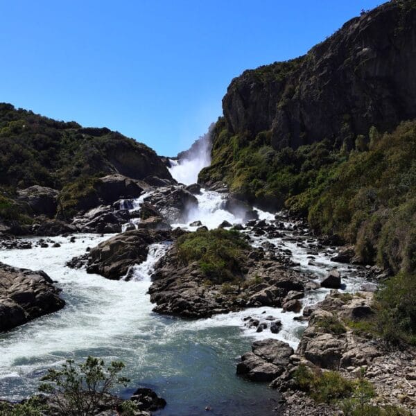
The drive from Puerto Río Tranquilo to Cochrane takes only a few hours. Along the way you’ll find beautiful viewpoints worth stopping for. You’ll be driving almost the entire time next to a river, which creates stunning scenery. With mountains in the background, the landscape is picture-perfect. In fact, we felt that the final stretches of the Carretera Austral were the most beautiful, as the nature here is much wilder than in the north. The road is also in worse condition, which adds a certain charm—though it’s not always comfortable to drive.
Be sure to stop at the viewpoint next to the river, as shown in the photo above (on the right).
Day 13: Cochrane
Distance: 50 km
Activities: hike in Patagonia National Park
Our final stop on the Carretera Austral in Chile is Cochrane. Nearby lies Patagonia National Park, where you can do several hikes. We walked to the bridge just before the park entrance. There is no entrance fee for this hike, and along the way you’ll see many guanacos.


Accommodation During the Carretera Austral Road Trip
Normally we always book accommodation through Booking.com and then share specific recommendations. This time we used Airbnb and looked for places within the towns (outside of them there are very few options, with a few exceptions). Our advice is to book with free cancellation so you can adjust your travel plans if needed.
How Many Days Do You Need for the Carretera Austral?
We describe a road trip of about 13 days along the Carretera Austral, from Puerto Montt to Cochrane. If you want to continue on to Villa O’Higgins, you’ll need at least one additional day of driving and another day to explore the town. Ideally, plan a few extra days into your itinerary, as the weather doesn’t always cooperate. It’s very possible to have a full day of rain, and it would be a shame to keep driving and miss out on a beautiful hike.


