Everest Base Camp Trek Nepal: Our Story
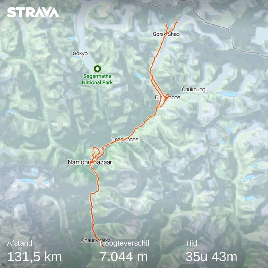
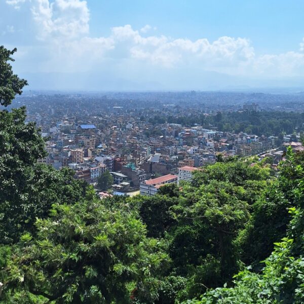
In October 2023 we flew from Thailand to Kathmandu, to start the trek to Mount Everest Base Camp a few days later. We previously wrote an article about our EBC experiences. Below you can read the complete story of our Everest Base Camp Trek in Nepal.
Day 1: Flight and Hike Lukla to Phakding
8.2km (2860m > 2610m)
“Be ready at 1 am” was the message last night. Sorry, what? Yes, the transport was supposed to leave at 1 am. Miracles still happen, because we managed to get about four hours of sleep. Less tired than expected (but still very tired) we stood in the lobby, with two backpacks and a large waterproof duffel bag (we got this quite unexpectedly last night, apparently there is a guide and a porter for the two of us). The reason for the early departure is the recent relocation of the airport from Kathmandu to Ramechhap. Although the airport is only about 100 km away, it takes us about four hours. Why? Just drive over a construction site, after three weeks of rain and you’ll know why…
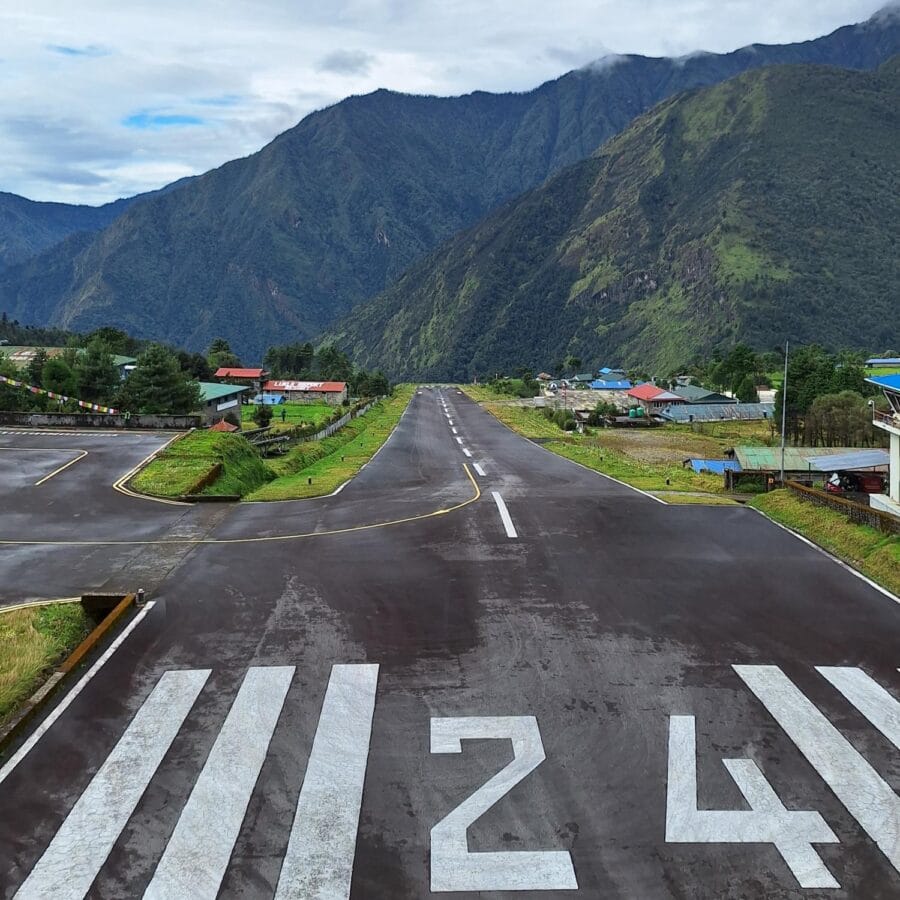
Around six in the morning we arrived at Ramechhap airport. The only way to reach the Everest Base Camp trek in Nepal is via Lukla airport. This flight is very notorious and is also known as the most dangerous flight in the world. Why? Lukla airport is literally in the mountains and has a runway of about 500 (!) meters. Only small propeller planes can land there and even then the runway slopes upwards because otherwise there is no way to slow down sufficiently.
Once the landing has started, there is no alternative. Then there are the weather conditions: if it is cloudy, flying is impossible and that can only be determined on the spot. And add to that the fact that Nepalese airlines (in Europe) are blacklisted because of the relatively many accidents.
However, the flight was the most beautiful we have had! It was more like a glider flight, but then between the mountains of the Himalayas! It was a smooth flight and ditto landing.
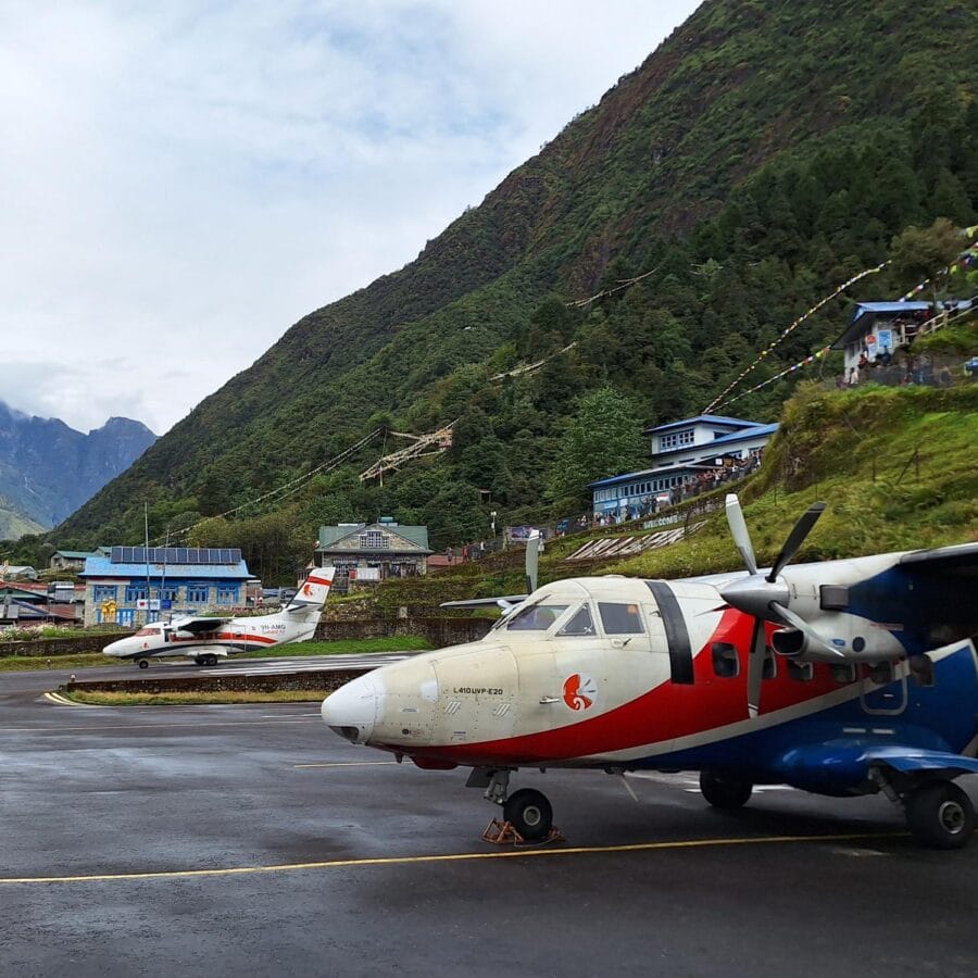
So we landed safely in Lukla. Finally we could start the Everest Base Camp trek Nepal, by far the most famous and visited hike in the country. First we got a typical Nepalese breakfast: lentil soup, naan bread and scrambled eggs. And that in a beautiful place, with a view of the airstrip where one plane after another arrived – and departed.
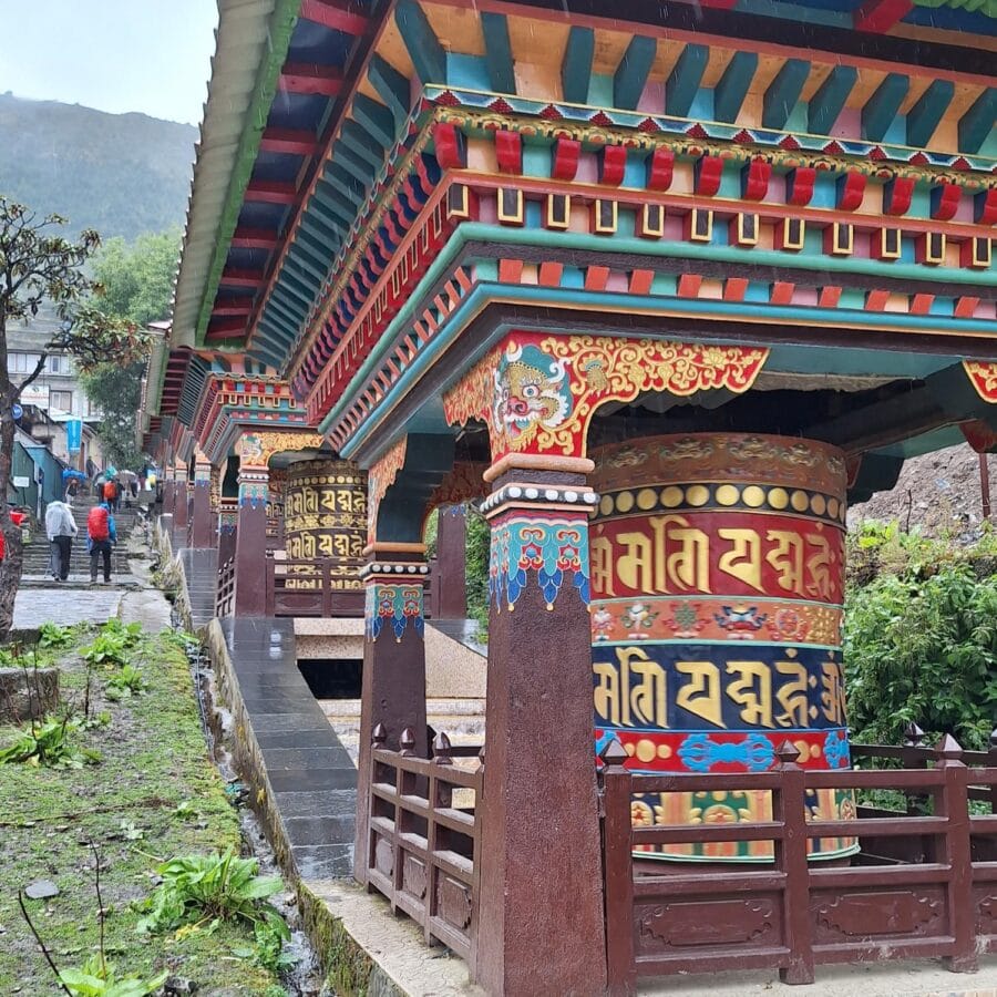
The first ‘hike’ is not very difficult, it is a wide path and on balance we descend. Great to get used to the Everest Base Camp trek, Nepal. We passed many cozy villages that breathe the Sherpa culture: colorful flags, the sounds of cowbells, the Nepalese porters and guides and of course the views of the Himalayas. We were also accompanied by both a guide (sherpa) and a porter for the next two weeks. Deep respect for both: our guide has already been to Mount Everest, and our porter could carry a lot of weight! We felt a bit guilty so we decided to put some extra weight in our own bags the next days 😉
Day 2: Hike Phakding to Namche Bazar
11.3km (2610m > 3440m)
We slept quite well last night. It may be child’s play so far, but we have never stayed overnight at this altitude. The alarm goes off at six o’clock and after a quick pack and breakfast we leave around 7.30. It had rained a lot last night, but in the morning it was sunny! The hike from Phakding to Namche Bazar is flat for a while (not really flat, but Nepalese flat, so just up and down). We passed the famous suspension bridges over the Dhudh Kosi river, among other things. It was about six kilometer to the lunch spot, where we were already having lunch around 9.30am.
The best choice for lunch during the Everest Base Camp trek in Nepal, is the local Dal Bhat. Or as the locals say: power food. This dish consists of rice, lentil soup, fried spinach, naan bread and vegetable/potato curry. Everything in small portions, but they keep asking if you want more! That extra food is really needed for the second part of the hike, the climb of about 500 metres to Namche Bazar. Although this climb seemed to be quite difficult, it was not too bad. We arrived around 12 noon at 3440 meters! Namche Bazar is the last village with somewhat basic facilities, such as electricity and hot water. Everything here has come the same way as us, by the hundreds of porters and yaks that travel the route every day. Really, what these people carry on their backs, the average person cannot even carry ten meters! Unbelievable!
Day 3: Acclimatization at Namche Bazar
10.4km (3440m > 3880m > 3440m)
Staying at high altitude for a longer period of time is not without risks. There is less and less oxygen in the air, which your body has to get used to. That is why day 3 is acclimatization day: that means nothing more than staying at the same altitude and getting used to the oxygen level. Watch out: it is not the same as a rest day. That is why we hiked to the higher village of Khumjung. Walking higher and sleeping lower promotes acclimatization. The highest point we reached was the Everest View Hotel at 3880m. For comparison: that is higher than the Großglockner, the highest mountain in Austria! And just a little higher than the highest point we have ever been.
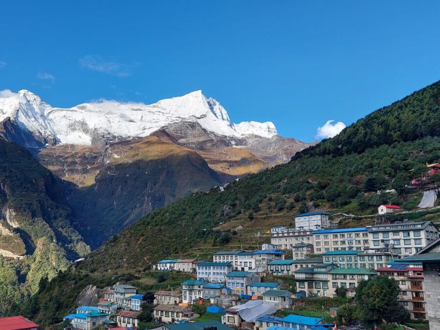
The past few days the weather was reasonable, the third day is was really bad (picture of Namche Bazar is from another day). It rained all day long! So we didn’t really have the beautiful views we had hoped for so far. What is going well, is our physical condition. We slept reasonably well again last night, and that at an already respectable altitude of more than 3400 meters above sea level. The heart rate and oxygen levels were also fine (these are checked sometimes). And we have not really had AMS (Acute Mountain Sickness) symptoms yet. Fortunately, because in the coming days we will climb another 2km(!).
Day 4: Hike Namche Bazar to Pangboche
13.8km (3440m > 3910m)
It was quite busy on the Everest Base Camp Trek. Normally that is not really fun for a walk, but here there is a completely different atmosphere. There is only one path and everyone has the same goal: reaching EBC. There is a very positive atmosphere in the air, despite the fact that it is sometimes really tough. We often had a chat with other hikers, sometimes on the way, but mainly in the teahouses.
For example, last night we had a chat with two Australians, one of whom was going to climb a mountain after EBC. And from two others (mountaineers) we learned two new games: “Monopoly deal” and “Pass the pigs” (the latter was hilarious). Incidentally, one of them had lost his backpack, which a porter had left at the wrong place. And there were many more conversations like that, always starting with questions: how are you? How long have you been here? Which way are you going? Is it hard? Do you suffer from altitude sickness? If we could spread this atmosphere across the world, there would never be war again!
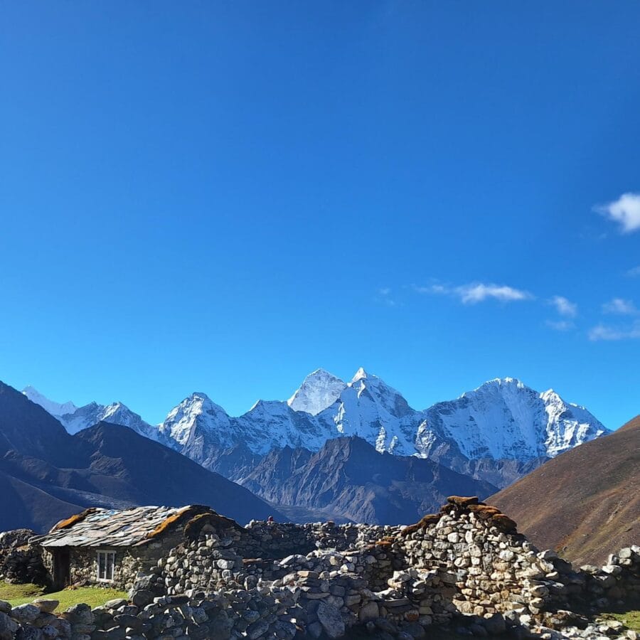
At this point we could see the mountain tops for the first time! We started the first part in good spirits, which is fairly flat. But then, the inevitable climb to Tengboche: 550m ascent to almost 3900m! For the first time this trip was really tough. The sun was shining brightly and we were really starting to feel the altitude. Maybe the breakfast (only an omelette) was not a good idea. But: once at the top, the hard work was rewarded. We saw Mt Everest and Mt Lhotse for the first time! And then there are all sorts of beautiful views of other mountain tops! We still had a short distance to go to today’s end point, where we arrived around 1pm. All in all a great day!
Day 5: Hike Pangboche to Dingboche
8.2km (3910m > 4330m)
We slept reasonably well last night, but Meike had a problem with her intestines (or the other way around?). This is a fairly common problem at altitude, but has nothing to do with AMS. So, we could continue, it was only a short stretch and there were no steep parts, only a bit uphill.
Then the positive part: it was really a great day! Blue sky, a nice sun at about five degrees and a view of all the peaks around us! We took our time for the great views and countless photos. Still, we arrived at Dingboche quite early. Again a colorful village, completely isolated from the rest of the world. Here you’ll find no electricity or hot water anymore. Only drinking water is boiled with the help of converging sunlight.
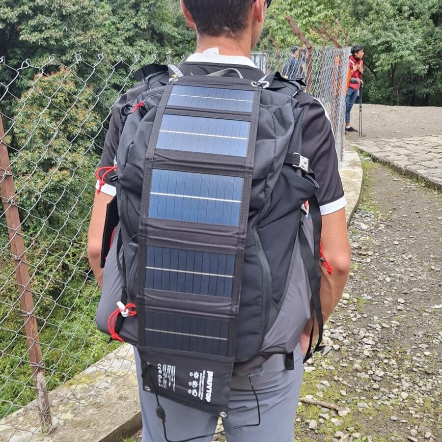
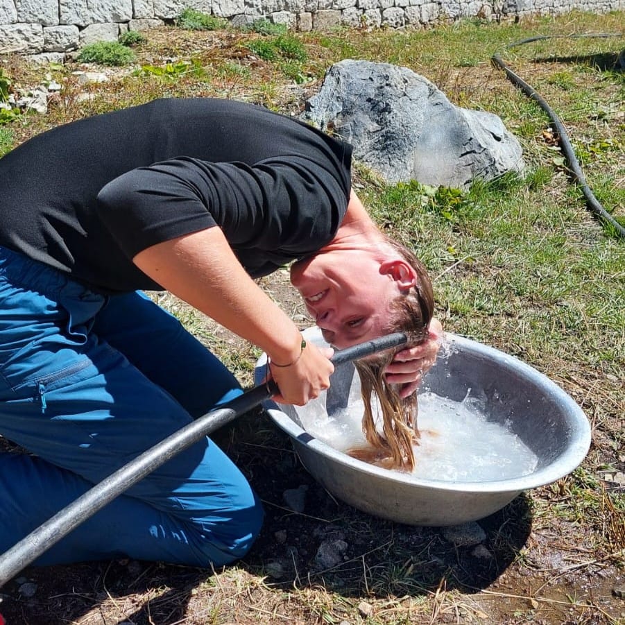
We washed our clothes by hand and the same went for our hair. Charging phones is slowly costing a fortune (about 3-4 euros each time, a power bank twice as much) and the same goes for a liter bottle of water. No problem, because our water bottle with filter worked perfectly! We have been drinking tap water for days (which probably comes straight from the mountain). And let’s not forget the solar charger. Two essential items for this trip! We treated ourselves to a good cappuccino in the afternoon at three euros each, which is a fortune by Asian standards.
Tip: with the code wetraveloutdoor you’ll get a 10% discount on the water-to-go bottle.
Day 6: Acclimatization Dingboche
2.8km (4330m > 4600m > 4330m)
Day 6 was another acclimatization day, before the last part to the end point. It’s about time, because the stay at altitude is starting to become noticeable. Although we haven’t had any AMS symptoms so far, the nights are getting shorter. About 4-6 hours of sleep is – if we are to believe various guides – not a bad night. Let’s just say that we didn’t have ‘bad nights’. Meike didn’t suffer as much, but had some problems with her intestines. All in all, things went still really well, but sometimes it took some perseverance. By the way, the route of day 6 was very short, from the village we walked up the adjacent hill. Still, we reached a respectable 4600m. We spent the rest of the day washing clothes/hair, drinking tea and resting as much as possible. Nothing to complain about the weather today, it’s sunny again!
Day 7: Hike Dingboche to Lobuche
8.7km (4330m > 4910m)
Finally: a good night’s sleep! Just the full eight hours, unheard of (for Pim, Meike always sleeps)! And the weather was also perfect! We left the cozy village of Dingboche and walked the first part along former glacier terrain. Mostly a false flat uphill until the lunch place Thukla, where we ate a Dal Bhat (again). Meike in particular was slowly getting tired of this dish. But hey, it is very nutritious! And, not entirely unimportant, this dish is the only one that is refilled unlimitedly if you are still hungry – and you are.
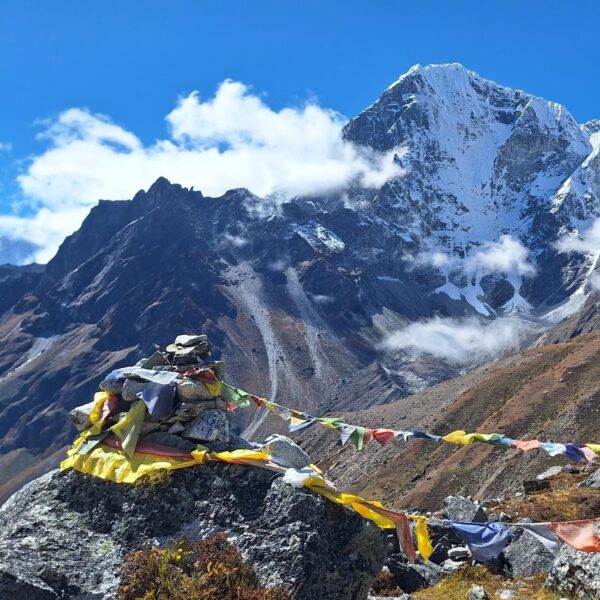
Immediately after lunch followed a steep climb. Although it was ‘only’ 200 meters in altitude, at this altitude you feel every meter. It went up slowly. At the top we reached the magical border of the Mont Blanc almost to the meter: 4808 meters! The last part was again a false flat uphill, a relatively relaxed end for today. The landscape changed more and more into high mountain terrain and the highest peaks came closer and closer. Especially the view of Mt Nuptse (behind which Mt Everest is temporarily hidden) was very beautiful.

Day 8: Summit Day, Lobuche to Gorak Shep
15.8km (4910m > 5640m > 5160m > 5360m > 5160m)
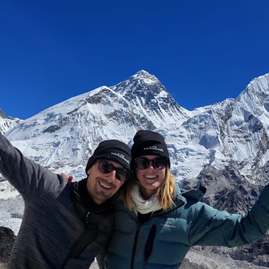
Day 8 was “summit day!”, as the mountaineers say. Could we call it that? Actually not really, because the peaks here are of course much higher. But still, 5640m altitude above sea level! That is quite an achievement! We left a bit earlier today, at 7.15 we left Lobuche behind us. We walked the first part to Gorak Shep (where we also spent the night) in record time.
It went really well so far. We were even so early that we decided to go to the top before lunch: Kala Patthar (5640m). Although some signs indicate a different height, this should be the official height. Actually, this part was planned for tomorrow, but we were in good shape and it wasn’t even 10am. And the weather was great; you should never waste good weather in the mountains! It was still about two kilometers and from the village another 500 meters of altitude, we can fix that – we thought. We have never underestimated something so much as this. These last kilometers became the toughest of our lives. Steeply up, gasping for breath (and also not eaten enough). It was tough. Especially the last 100m it was slow, a snail would overtake us (well, Pim, Meike was just a bit faster).
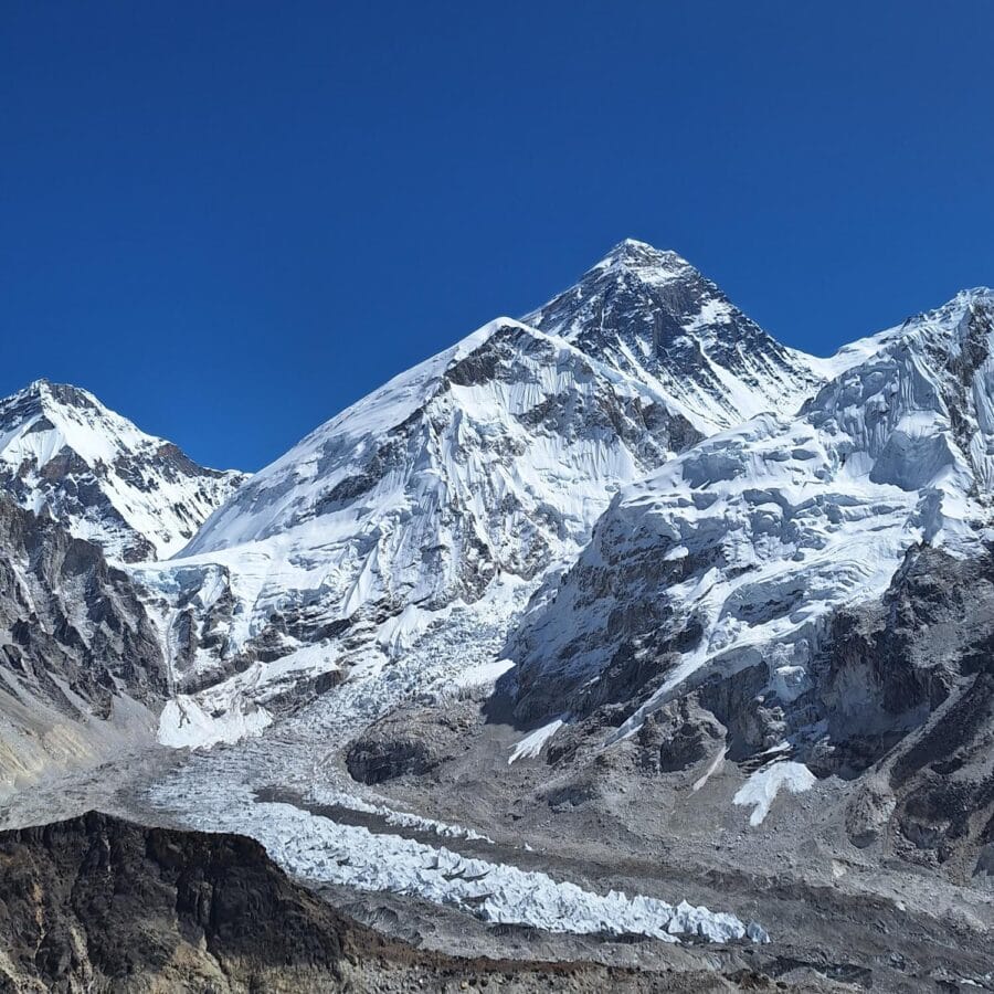
Around 10.45am we were finally at the highest point of the route, and perhaps of our lives! The view was truly phenomenal: Mount Everest, Nuptse, the Khumbu Icefall, Everest Base Camp, all under a clear blue sky! And that’s just one side. In front of us we saw the (endless) glacier plains where we came from and to the right there was a view of the Chola Pass (a possible extension of this route) and many other peaks. We enjoyed the view (all by ourselves) for half an hour and after a lot of photos we walked back. The people we saw stumbling up the mountain in all that time, were still not at the top (so we were not the only ones, everyone has to fight).
Our limits had more or less been reached at this point during lunch. But we had to continue (by ourselves), because EBC is also on the schedule for day 8. From tomorrow on we only want to go down. It was another three kilometers one way, but much less heavy. Unfortunately it was incredibly busy (many people only come here by helicopter to take a picture). The trip to Kala Patthar was much more fun for us, but of course we have to see the official end point!
Day 9: Back to Pangboche
18.7km (5160m > 3910m)
Living above 5000m is not exactly a pleasure. You get out of breath from literally everything. And the overnight stays at this altitude are not great either. We also had no more “luxury” (a lamp and running water) the last two nights. In that respect we have had enough, especially now that we have reached the end point. We therefore decided to descend as far as possible today. And although it was a fairly long walk, it was not extremely difficult. We went almost exclusively downhill and breathing became easier by the minute. Where we were supposed to spent the night in Pheriche, the end point today is Pangboche. As a result, we were one day ahead of schedule.
That was perhaps a good thing, because the airport of Lukla was a disaster. Where we always had perfect weather, it has apparently been so bad down there that there has not been a single flight for 5(!) days (they do not fly in poor visibility, which you immediately understand when you see the runway). And then you are stuck there. Tomorrow we will first descend further towards Namche Bazar.
Day 10: Back to Namche Bazar
14.1km (3910m > 3440m)
We already walked down a long way yesterday, from glacier terrain to the tree line. It felt like we were back in the valley. Nothing could be further from the truth, today we need to go further down. The first part was still okay. After an hour we arrived in Tengboche, where at that exact moment a ceremony (or whatever it is called in Buddhism?) began in the monastery. We were allowed to watch a bit. Unbelievable how dedicated these monks are, they will keep this activity up for three times three hours every day for the next week! We couldn’t stay that long, because we had to catch a plane in a few days.
From this point, there was no flat terrain to walk anymore. The first part went steeply down, then hundreds of meters of climbing again and then continuously up and down. Was it that long on the way there too? Someone seemed to have changed the route! It was endless, but eventually we reached Namche Bazar. We were finally somewhat back in the civilized world. That’s called: we had a room with lighting and electricity! And there was a shower – which still costs a fortune, but still. And a pot of tea also costs a little less, so we immediately had one upon arrival at the tea house.
Day 11: Back to Lukla
19.0km (3440m > 2860m)
The last day of the Everest Base Camp Trek in Nepal was tough, very tough. It’s still 19 km to Lukla (with a lot of elevation). We were both tired and had caught a cold (not surprising with a resistance of 0). And Meike in particular had big blisters. After the first stage (a lot of downhill) we had lunch in Phakding. Not that that helped much, the energy level was still at zero. But we had to keep going for a while. Before we left again we had to wake up our guide. He was also very tires by now. The last 8 km to Lukla are uphill. We continued at a walking pace, until we finally arrived around 3 pm!