Carretera Austral Itinerary: Highlights by Car!
In the south of Chile, from Puerto Montt to Villa O’Higgins, runs the famous Highway 7: the Carretera Austral. This 1,200-kilometer-long road takes you past stunning viewpoints, beautiful rivers, waterfalls, and hiking trails. This part of Patagonia is still relatively undiscovered by backpackers and therefore much quieter than, for example, Torres del Paine National Park further south. We drove the Carretera Austral round trip in November 2025 because our rental car had to be returned in Puerto Montt. Below, we share a complete Carretera Austral itinerary from Puerto Montt to Cochrane and back. This way, you can drive the Carretera Austral yourself!
How Many Days Do You Need for the Carretera Austral?
Below you’ll find a rough day-by-day plan if, like us, you have to drive the Carretera Austral out and back. Are you able to drive the entire route all the way to Villa O’Higgins? Or do you not need to return the same way? Then check out our article on the complete Carretera Austral itinerary for a detailed day plan. For a round trip, you’ll need at least 17 days.
- Puerto Montt – Hornopirén
- Hornopirén – Chaitén
- Chaitén – Villa Santa Lucía
- Villa Santa Lucía – Puyuhuapi
- Puyuhuapi – Coyhaique
- Coyhaique – Villa Cerro Castillo
- Villa Cerro Castillo – Puerto Rio Tranquilo
- Puerto Rio Tranquilo – Cochrane
- Cochrane
- Cochrane – Puerto Rio Tranquilo
- Puerto Rio Tranquilo – Río Ibáñez
- Río Ibáñez – Coyhaique
- Coyhaique – Puyuhuapi
- Puyuhuapi – Futaleufú
- Futaleufú – Chaitén
- Chaitén – Hornopirén
- Hornopirén – Puerto Montt

Carretera Austral Day-by-Day Itinerary
Day 1: Puerto Montt – Hornopirén
Distance: 110 km
Activities: Pick up rental car, grocery shopping, short ferry crossing
The first day of the Carretera Austral is mainly practical: you pick up your rental car and do some grocery shopping in Puerto Montt. We went to a large supermarket where prices were very reasonable! After that, you drive to Hornopirén, which requires a short ferry crossing. You don’t need to reserve this ferry, but it can be helpful to check the schedule in advance. Luckily, we were able to drive straight onto the boat. There is also an alternative route that doesn’t require the ferry, but this route is mostly unpaved. You could save that option for the return trip.
Day 2: Hornopirén – Chaitén
Distance: 150 km
Activities: Ferry Hornopirén–Caleta Gonzalo (reserve in advance), hike in Pumalín Douglas Tompkins Park or Chaitén Volcano
The ferry crossing to Caleta Gonzalo takes about 5 hours, depending on the sailing route. We read that sometimes you have to drive a short stretch in between and then board another ferry. Our crossing was direct, which was very pleasant. You’re allowed to walk to your car during the trip to grab supplies or prepare food. There’s also food for sale on board.
From Caleta Gonzalo, it’s about a one-hour drive to Chaitén. If the weather allows and you still have energy, the hike up the volcano is a great option. It takes about 2 to 3 hours and involves quite a bit of elevation gain. All in all, it makes for a long day, so you could also save this hike for the return journey. Just after disembarking from the ferry, there’s also a 3-kilometer hike starting on the right-hand side of the road. On our Google Maps Guide Patagonia, you’ll find all hikes up to Chaitén.


*It may happen that your preferred dates aren’t listed on the website yet. This means the ferry hasn’t been confirmed. If that’s the case, check again two weeks in advance—the ferry does operate daily.
Day 3: Chaitén – Villa Santa Lucía
Distance: 75 km
Activities: Pumalín Douglas Tompkins Park, Corcovado National Park
The drive from Chaitén to Villa Santa Lucía is short, so you can stop at another entrance of Pumalín Douglas Tompkins Park along the way. About 20 kilometers south of Chaitén, you’ll find three hikes ranging from short to long. We did the short hike but would definitely have done the other two if time had allowed. You can already see the glacier in the distance, and the longer hikes take you closer.
In Corcovado National Park, you’ll find the Yelcho Glacier. Here, you can take a short walk to a viewpoint, which is definitely worth it.


Day 4: Villa Santa Lucía – Puyuhuapi
Distance: 120 km
Activities: Hanging Glacier, waterfall
If the weather cooperates today, visiting the Hanging Glacier is absolutely worth it. Leave Villa Santa Lucía early so you arrive at the park on time. This is the first park where you have to pay an entrance fee and make a reservation. Along the way, you’ll also pass a waterfall that’s visible from the road, though it’s not a must-stop.


Day 5: Puyuhuapi – Coyhaique
Distance: 240 km
Activities: Hanging Glacier
Is the weather better today? Then plan the Hanging Glacier hike in the morning and drive to Coyhaique in the afternoon. At the time of writing (December 2025), Queulat National Park is undergoing major maintenance, meaning not all trails are open. The hike that brings you closest to the glacier has been closed for several months. Still, there are multiple viewpoints where you can see the glacier, making this park well worth a visit.
Day 6: Coyhaique – Villa Cerro Castillo
Distance: 100 km
Activities: Hike to a glacial lake
The route from Coyhaique to Villa Cerro Castillo is absolutely stunning, with several viewpoints right along the road. In Cerro Castillo, you can hike to a glacial lake, but you need to start early. The trail is 13 kilometers long and involves significant elevation gain. We skipped this hike due to the high entrance fee and additional parking costs. There are plenty of beautiful places in this part of Patagonia that are free to visit.
Day 7: Villa Cerro Castillo – Puerto Río Tranquilo
Distance: 120 km
Activities: Viewpoints, reserve Marble Caves tour
Today you’ll spend most of your time driving, though not the entire day. We saved several scenic stops on our map so you can enjoy the views along the way. In the evening, reserve your Marble Caves tour for the next morning. In high season, you may need to book earlier, but during the low season this isn’t necessary. You book the tour on-site in the street where all the tour operators are located.
Day 8: Puerto Río Tranquilo – Cochrane
Distance: 120 km
Activities: Marble Caves tour
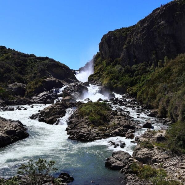
Start your day with the boat tour to the Marble Caves, something we believe is a must-do on the Carretera Austral. The caves were formed during the glacial period in this part of Chile. Keep in mind that many photos you see online are heavily edited. After the tour, continue on to Cochrane. Road conditions vary, but during our visit it was dry, which helped a lot.
Tip: make a stop at the viewpoint on your way to Cochrane to look at the river (picture right).

Day 9: Cochrane
Distance: 50 km
Activities: Patagonia National Park
Near Cochrane lies Patagonia National Park, where you can do several beautiful hikes. We did a roughly 10-kilometer hike to a bridge just before the park entrance. The trail is fairly flat, passes guanacos, and offers a great view from the bridge in good weather.


Day 10: Cochrane – Puerto Río Tranquilo
Distance: 120 km
Activities: Viewpoint hike, Patagonia National Park
On the return trip, you can choose to hike again in Patagonia National Park or drive straight back to Puerto Río Tranquilo. Due to a midday road closure, we chose the latter. In Puerto Río Tranquilo, you can hike up to a rock that offers an amazing view over the village and the lake. With snow-capped mountains in the background, it’s truly picture-perfect! The trail isn’t very well marked, and at one point you’ll need to hold onto a rope. In our Google Maps travel guide Patagonia, we’ve included a GPX file to help you find the route.
Day 11: Puerto Río Tranquilo – Río Ibáñez
Distance: 160 km
Activities: Glacial lake hike Villa Cerro Castillo
Río Ibáñez isn’t located on the main Carretera Austral route, but it’s still worth a visit. The village is very small, but you’ll pass a beautiful and powerful waterfall. What made our stay here special was the campsite, which is really only accessible by 4×4. We stayed in a cabin surrounded by nature! If you leave early, you could also attempt the glacial lake hike in Cerro Castillo today if you didn’t do it on the way south.
Day 12: Río Ibáñez – Coyhaique
Distance: 115 km
Activities: Grocery shopping
Once back in Coyhaique, it’s time to get new groceries and stroll around town. There’s a park just north of the city, but we didn’t find it particularly worth visiting. A rest day during the Carretera Austral isn’t a bad idea! You could also use this day as a buffer in case you had bad weather earlier in the trip.
Day 13: Coyhaique – Puyuhuapi
Distance: 240 km
Activities: Hanging Glacier
Tip: If the weather absolutely didn’t allow you to visit the Hanging Glacier on the way south, today and tomorrow are your last chances! The drive from Coyhaique is long, so plan accordingly. After a certain time, you’re no longer allowed to enter the park.
Day 14: Puyuhuapi – Futaleufú
Distance: 190 km
Activities: Rafting
Like Río Ibáñez, Futaleufú isn’t on the official Carretera Austral route, but it’s well worth a visit for its water-based activities. The river here is perfect for rafting! Book your tour in advance for today or tomorrow. It’s easy to combine with the drive to the next destination. In Futaleufú, you can also visit a scenic viewpoint overlooking the river. Despite some steep sections, this route is accessible with a regular car.


Day 15: Futaleufú – Chaitén
Distance: 150 km
Activities: Corcovado National Park, Pumalín Douglas Tompkins Park
If you didn’t hike to the Yelcho Glacier on the way south, today is another opportunity. The drive from Futaleufú to Chaitén doesn’t take long, and the hike itself is short. In the late afternoon, you may also have time to do one of the hikes in Pumalín Park (entrance south of Chaitén).


Day 16: Chaitén – Hornopirén
Distance: 150 km
Activities: Ferry (book in advance)
It’s time to take the ferry back to Hornopirén. The ferry departs either at 4:00 PM or 4:00 AM. We chose the afternoon option, which allowed us to do a few short hikes in the morning. These hikes are listed in our Google Maps travel guide Patagonia.
Day 17: Hornopirén – Puerto Montt
Distance: 110–250 km
Activities: Puerto Varas
From Hornopirén to Puerto Montt isn’t far, and there are two routes you can take: one with a ferry or a longer detour. The detour is mostly unpaved and not very great to drive in the rain. Today marks the final day of the Carretera Austral road trip, so you’ll also return your rental car.
Tips for Driving the Carretera Austral, Chile
During our preparation, we read many horror stories about the roads. Google Maps shows long unpaved sections, but in reality it’s not that bad. Yes, parts of the road are unpaved, but there are also many paved sections. On Maps.me, you can usually see fairly up-to-date information (with some exceptions!) on which sections are paved or unpaved. Don’t let this discourage you from driving the Carretera Austral yourself!
Tips for Car Rental on the Carretera Austral
Normally, we’re big fans of Sunnycars because of their excellent insurance coverage. This time, however, we chose a local rental company because Sunnycars doesn’t provide a spare tire and doesn’t allow driving on unpaved roads. Renting near Puerto Montt is recommended. If you want to drive the full Carretera Austral, rent through Prime Rent a Car!
Cost of the Carretera Austral Itinerary
A trip through Patagonia sounds expensive! In the end, the costs were very reasonable, especially along the Carretera Austral. With two people, we spent €2,100 over 18 days. In our article about the costs of traveling the Carretera Austral, you’ll find a detailed breakdown of our expenses.